Navigating by the stars served sailors well for hundreds of years, and should you find yourself in a bad spot, you can still use it today. Nowadays, we mostly rely on electronic navigation methods, such as GPS devices or compasses and maps.
What if you don’t have any of that? Whether it’s a matter of life and death or you just want to try out a new challenge, knowing how to navigate by the stars is useful — and cool! — skill.
Let’s take a look.
The Most Important Constellations
You can use the stars to determine north, south, east, and west and figure out your latitude and longitude, but to do that, you need to learn a few constellations first.
For all you astronomy enthusiasts out there, I’m aware that the Dippers aren’t actual constellations but asterisms. For the sake of clarity, I’ll refer to them as constellations in this article.
The Big Dipper, the Little Dipper, and the Southern Cross are the three most important constellations for navigation.
The Big Dipper
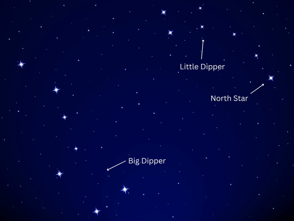
Also known as the Great Bear or Ursa Major, the Big Dipper is important for locating the North Star. As the name implies, that star will lead you north, but more on that later.
How do you identify the Big Dipper?
First of all, you have to find yourself in the northern hemisphere — you can’t use the Big Dipper for navigation in the southern hemisphere (that’s what the Southern Cross is for).
In springtime, the Big Dipper is usually high up in the sky, and it falls down closer to the horizon in the fall.
The Big Dipper is often brighter and easier to find than the Little Dipper, and we use it to locate the Little Dipper since the two constellations are always close.
The Big Dipper looks like a ladle or a bent paddle — that’s what you have to look for in the sky.
There is a distinct bend at the end of the handle of the ladle — three stars form a straight line, and the last star in the constellation is not in line with them.
This is how you know you’re not mistaking the Little Dipper for the Big Dipper; the Little Dipper’s handle is consistently curved, and there are no aggressive bends.
The Little Dipper
The North Star is part of the Little Dipper constellation, so it’s crucial we find the Little Dipper to orient ourselves in the wild.
The shape is almost identical to that of the Big Dipper but smaller, and the handle of the ladle is slightly curved. There are no strong bends like with the Big Dipper.
Two things need pointing out:
- The Little Dipper isn’t as bright as the Big Dipper, and on some nights, it’s impossible to locate it because of this.
- It’s very easy to mistake the Big Dipper for the Little Dipper.
Keep these two things in mind when you’re looking for the Little Dipper. You don’t want to follow the wrong star.
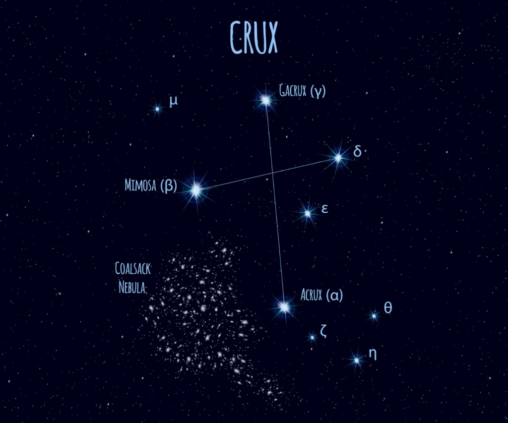
The Southern Cross
The Southern Cross never rises above the horizon in the Northern Hemisphere (some observers in southern Florida are able to catch it, but only a few times in May and for short periods). Therefore, it’s only useful for navigators in the southern hemisphere.
As the name suggests, this constellation looks like a cross. There are four stars (Gacrux and Acrux, Delta Crucis and Mimosa), and if you draw two lines between them, you get a cross.
The Southern Cross is also kite shaped. If you were to draw a line from one star to another to close their shape, you’d get a kite.
The best way to identify the Southern Cross, however, is by using your body. Find the four stars you suspect are the Southern Cross and extend your arm. Using your index, middle, and ring fingers, measure the width of the constellation.
Since it’s such a small constellation, it shouldn’t be wider than your three fingers at arm’s length (unless you have insanely long arms).
One final tip: Use the Jewel Box to make sure you’re on the right track. The Jewel Box is a small cluster of stars located diagonally on the bottom left of the Mimosa star (the left star of the Southern Cross), very close to it.
If you imagine a compass over the constellation, the Jewel Box would be located southwest of the Mimosa or at 7 o’clock if you want to use a clock for scale.
How to Navigate by the Stars
Now that we know our constellations, it’s time to use them, and their stars, for navigation. The first one we’ll look at is the North Star.
Using the North Star to Navigate
The North Star, also known as Polaris, is the last star in the Little Dipper constellation, affectionately referred to as the tail of the Little Dipper.
It’s always above the North Pole, and it’s almost precisely north. It moves in very small increments, mostly staying in the same spot, with the rest of the stars revolving around it.
Because of this, you can always count on it to lead you north.
Once you have that information, south, east, and west are all pretty easy to find. If you face the North Star, south is behind you, east is on your right, and west is on the left.
Using the Southern Cross to Navigate
The Southern Cross can be used to locate the South Pole, just as the North Star is used to locate the North Pole.
Again, you can only use the Southern Cross for navigation in the southern hemisphere, while the North Star is used in the northern hemisphere.
When it’s at its peak, the low end of the Southern Cross (the Acrux Star) is pointing directly south. If you face it, you’re facing south, your back is facing north, east is on your left, and west is on your right (the opposite of North Star navigation).
People have trouble locating south when the Southern Cross isn’t at its peak, but there’s a simple method for that too.
Use your fingers to “draw” a straight line from the top star of the Southern Cross (Gacrux) to the bottom star (Acrux). Now, using your fingers, replicate that line about 4.5 times (this won’t be perfectly precise, but it’s much more accurate than relying on Acrux only).
The point beneath your finger after you’ve drawn the last line is south.
Find North with Any Star

- Lie on the ground. Locate any bright star.
- Push a stick into the ground so it’s at eye level.
- Push a slightly longer stick into the ground behind the first stick. The top of both sticks should line up with your view of the star.
- Watch the star for approxiately 10 minutes
- If the star moves to the left of the stick, you are facing north. If it moves to the right, you are facing south. If the star moves up, you are facing east. If the star moves down, you are facing west.
How to Determine Latitude and Longitude by the Stars

Traditionally, sailors used a sextant to determine their latitude by the stars. Even today, a lot of sailors have modern sextants on their ships, just in case something goes wrong with their GPS devices.
If you want to try it, you can buy a modern sextant and figure out your latitude, but what if you don’t have a sextant?
Not a problem! The first thing you have to do is find the North Star or determine where south is using the method explained in the previous section.
Then, extend your arms in front of you and make fists. Start placing your fists one on top of the other until you reach the North Star or the south with them. Each fist is about 10°.
This, of course, is not as nearly as accurate as a GPS device or a compass, but it’ll give you a good idea of where you are on a map if you have one.
By calculating your longitude, you can give your approximate grid to search and rescue if you manage to contact them.
Calculating Longitude
Unfortunately, there’s no way to determine longitude using the stars, but you can use your watch to do it.
However, you have to do this during the day, not at night.
It’s very simple: Make sure you know the time difference between your current location and England (if you’re traveling somewhere, check it beforehand) because that’s Greenwich Mean Time. You could even consider turning your clock to British time.
At Greenwich, the sun is highest at noon, precisely 12 p.m. However, this doesn’t apply to the entire world. Observe when the sun is highest in your location. For example, if the sun is highest at 3 p.m. (British time) at your location, it’s three hours behind Greenwich.
One hour of time difference is precisely 15 degrees of longitude, according to the University of Nebraska-Lincoln. Multiply 3 with 15° and you’ll get 45°. Your longitude is somewhere around 45°.
Just like with latitude, this isn’t pinpoint precision, but it’s somewhat accurate, and you can partly get the grid you’re located in with this method.
What Do You Do With This Information?
The question is, now that you know where north and south are, or now that you know your approximate latitude and longitude, what do you do with it?
If you have a map, you can use the directions to navigate at night. If the North Star falls behind a very specific peak or hill, you can use that as a navigation point during the day as well.
You can also determine your map grid if you know your latitude and longitude, making navigation a whole lot easier.
If you get lost and you can contact search and rescue, you can give them the approximate coordinates, and you’ll get rescued sooner.

i used this to navigate my way through the sea like moana im so cool suck my cock please ill pay now NOW NOW NOW